Week 3: Cartography
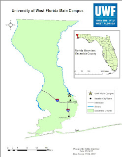
This was a pretty big week: I made three maps! It was actually really easy to make three different maps once the base layer was made. I saw the ArcCatalog this week and it was much easier to look through the metadata for the files in ArcCatalog as opposed to right-clicking each of the files in the table of contents and finding the data there. I had some trouble with labels, they were sometimes hard to read or they made the map feel cluttered, at least to me. There was a part in this lab where there were limited directions and I was on my own. After double left clicking and right clicking some things, I was able to set up the map; time will tell if I set it up correctly, but it was set up. I liked being able to stretch my wings a little and figure out how to set up the elevation on my own. It was really satisfying to find all of the settings on my own.
Here are the maps that I worked so hard to make.


Here are the maps that I worked so hard to make.


Comments
Post a Comment