Computer Cartography - Week 2 Map Evaluations
This week we took a look at different maps through the lens of 20 principles for making maps. After looking at some poorly made maps, I realized many of those look somewhat like the maps I've made.
I looked at two maps a good one and one that has some room for improvement.
Here is the good map:

This is a map of the Watershed Above the Manasquan Water Supply system Intake.
This is a well made map because it easily expresses where the watershed is, where the farms are, and where water is taken in from. The symbols are easy to see and differentiate. The map has a nice layout with the smaller reference map above the legend and a very nice scale with some easy whole numbers to use. Overall this is a great map.
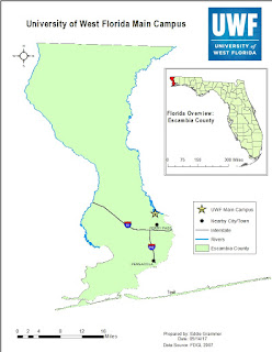
Here is a map that has some room for improvement:

I looked at two maps a good one and one that has some room for improvement.
Here is the good map:

This is a map of the Watershed Above the Manasquan Water Supply system Intake.
This is a well made map because it easily expresses where the watershed is, where the farms are, and where water is taken in from. The symbols are easy to see and differentiate. The map has a nice layout with the smaller reference map above the legend and a very nice scale with some easy whole numbers to use. Overall this is a great map.
Here is a map that has some room for improvement:

This map shows the various ways you can travel in... London , I think? This is a large map. I’m sure if this was blown up and put on a wall it would be much easier to see. Overall I think there is a bunch of unnecessary "map crap." If this is about transport, just put the transport on the map, leave off the other things like interchange stations, public buildings, and places of interest. Also, they might want to have only one type of transport on the map, like just the bus routes, just to keep people from getting distracted. There is some less than substantial information on this map too. The map definitely shows people every option they have to get around, however it is so complex; they could easily split this information into three or four different maps.

Comments
Post a Comment